
Get ready to learn about Morocco’s national flag and its place on a map. The Morocco flag map shows the country’s identity and its geography.
The flag was adopted in 1915. It has a deep red field with a green pentagram in the middle. This pentagram stands for the five pillars of Islam.
The red color means strength, bravery, and courage. It also ties back to the Alaouite dynasty.
By looking at the morocco map with flag, you’ll understand Morocco’s identity better. You’ll see how it’s shown visually.
Key Takeaways
- The Moroccan flag was adopted in 1915.
- The flag features a red field with a green pentagram.
- The red color symbolizes hardiness and bravery.
- The green pentagram represents the five pillars of Islam.
- The flag’s design has evolved over time.
The Symbolism of Morocco’s National Flag
Exploring Morocco’s flag reveals its deep historical and religious meaning. It shows the country’s fight for freedom and its faith. The flag is a symbol of Morocco’s identity.
The Red Background and Its Historical Significance
The red background of Morocco’s flag holds a lot of history. It stands for the country’s fight for freedom and its rich culture. Red also links to the Sharifian dynasty, which has led Morocco for ages.

The Green Pentagram: Meaning and Representation
The green pentagram in the flag’s center is key in Islam. It represents the five pillars of faith. This symbol shows Morocco’s strong Islamic identity and brings the people together.
The red background and the green pentagram make Morocco’s flag a powerful symbol. It shows national pride, the people’s strength, and their faith.
Historical Evolution of the Morocco Flag
Exploring Morocco’s flag history reveals a rich tapestry of designs. These designs have shaped the nation’s identity. The flag’s evolution reflects Morocco’s complex history, influenced by cultural and political factors.

Pre-Independence Flag Variations
Before Morocco gained independence in 1956, the country had several flag designs. The pre-independence era featured various symbols and colors. These reflected Morocco’s diverse cultural heritage and the influence of different ruling dynasties.
The use of red and other colors was prominent. They often symbolized different aspects of Moroccan identity and sovereignty.
Post-1956 Flag Development and Standardization
After gaining independence, Morocco standardized its national flag. The current design, with a red background and a green pentagram, was adopted. The green pentagram is particularly significant, representing the five pillars of Islam and symbolizing the country’s religious identity.
The post-1956 period saw the consolidation of the flag’s design. This design has remained relatively unchanged. It serves as a unifying symbol for the Moroccan people.
Understanding Morocco’s flag history offers valuable insights into the country’s national identity. It shows how the flag is represented on a map, like in a morocco atlas with flag. The flag’s design elements are often integrated into cartographic representations. This enhances the visual connection between the national symbol and the country’s geography.
Geographical Overview of Morocco
Exploring Morocco’s geography reveals its special spot in North Africa. Here, the Atlantic Ocean and the Mediterranean Sea meet. The Atlas Mountains also meet the Sahara Desert.
Morocco’s Strategic Location in North Africa
Morocco’s location is key for trade and cultural sharing. It borders Algeria to the east, Western Sahara to the south, and the Atlantic Ocean to the west. This makes Morocco a big player in regional and global affairs. Its close link to Europe, across the Strait of Gibraltar, boosts its role in commerce and diplomacy.
Major Geographical Features and Regions
Morocco’s geography is diverse. The Atlas Mountains run through the country. The Sahara Desert covers a big part of it. The country’s different areas, from coastal plains to mountains, add to its rich biodiversity and culture. 
Knowing these features helps us understand Morocco’s national identity, shown by its flag. The country’s geography has shaped its history, culture, and economy. It makes Morocco a fascinating place to learn about.
Morocco Flag Map: Integrating National Symbols with Geography
A Morocco flag map is more than a visual tool. It combines national identity with geography. This mix helps us grasp the country’s history and its people’s pride.
National Identity Through Cartography
Cartography skillfully merges the country’s flag with its geography. This isn’t just about looks. It’s about showing the importance of national symbols. By linking the flag with the map, cartographers tell a story of Morocco’s place in North Africa and its varied landscapes.
Looking at a Morocco flag picture map, you see the art of cartography. It shows Morocco‘s deep cultural roots and its people’s bond with the land.
Visual Representation Techniques
Many techniques are used to make a Morocco flag map engaging and informative. These include:
- Color coding to show different areas
- Symbolic uses of national symbols
- Elements that point out Morocco’s key location

Knowing these techniques lets us see the beauty and complexity of a Morocco flag map. It’s a mix of art, geography, and national pride.
The Cultural Significance of Morocco’s Flag
The Morocco flag tells a lot about the country’s culture and religion. It’s more than a national symbol. It shows Morocco’s history, values, and beliefs.

Religious Elements in the Flag Design
The flag’s design has important religious symbols, showing Morocco’s Islamic roots. The green pentagram, for example, links heaven and earth. It’s seen as a protective sign in Islam.
Cultural Pride and National Unity
The flag stands for cultural pride and unity in Morocco. It celebrates the country’s history and traditions. Seeing the flag reminds us of Morocco’s strength and shared identity.
Knowing the flag’s cultural meaning helps us understand its place on maps like the Morocco flag map. This map combines national symbols with geography, giving a full view of Morocco’s identity.
Morocco Map with Flag: Political Boundaries
Looking at a map with Morocco’s flag can help you understand the country’s identity. It shows the country’s geography and symbols. This helps us see Morocco’s national identity clearly.
Morocco is in North Africa’s Maghreb Region. It covers 710,850 sq. km. It borders Algeria, Western Sahara, and Spain. The Atlas and Rif Mountains, and the Sahara Desert are part of its geography.
To learn more about Morocco’s geography, check out worldatlas.com. They have accurate maps of Morocco.
Understanding Morocco’s political boundaries on a map is key. It shows the country’s complex history and identity. The map with the flag is a great way to see Morocco’s symbols and geography.


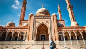


 Covers cities, coast, mountains, desert & food